In the next article we are going to take a look at an application called Geotagging. If you want view and mark location information on already captured photosIn the following lines we are going to see how to install the photo geotagging application. For this we will use its Flatpak package in Ubuntu.
Today, many people use offline computers to record their physical activities and adventures. These devices usually use the GPS network. In the midst of these activities / adventures, people often take pictures, and they can't always mark the place where the photo was taken. Fortunately it is now possible to do this manually, and correct this small flaw using location applications such as the Geotagging application.
Geotagging is the process of adding geographic information in the metadata of images, videos, sound, websites, etc. files. can help us for your georeferencing. In general, these data are usually coordinated that define the longitude and latitude where the multimedia file has been created. In some cases they may include altitude, place name, street and number, zip code, etc. to later find its geographic coordinates.
geotagging
There are several ways to add keywords with the geographic location of the data, most of which are based on the tagged description or the location with coordinates. Through geotagging, users can find a wide variety of information about a specific place. For example, it is possible to find images taken near a certain site, by entering its geographic coordinates in a search engine.
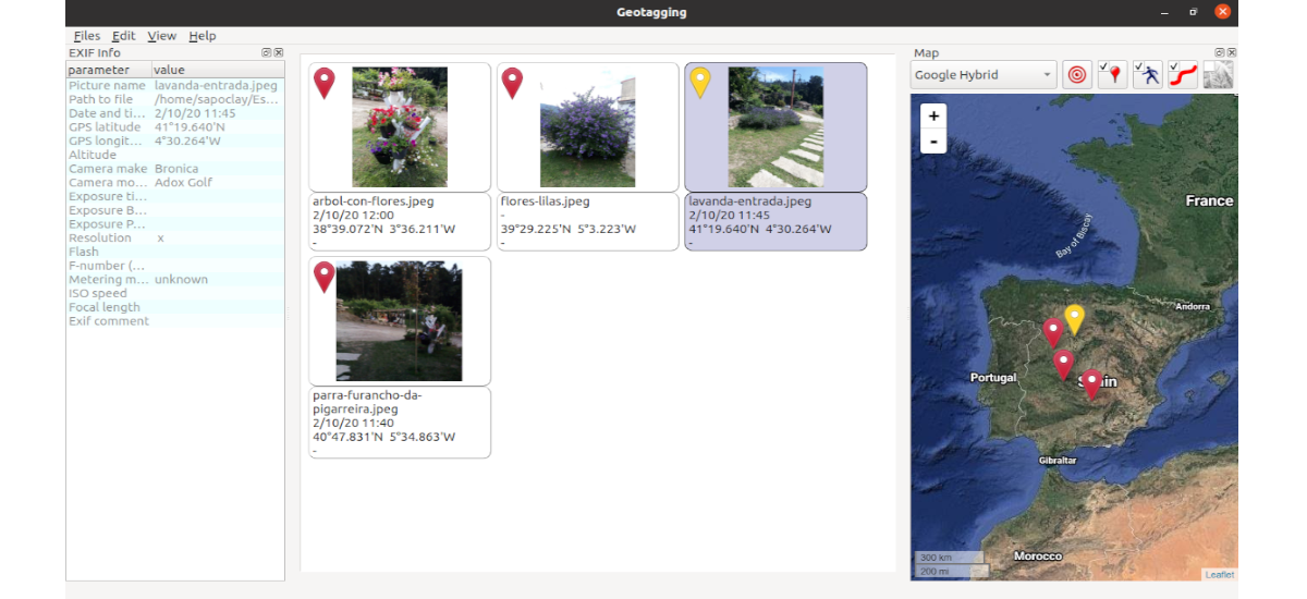
Geotagging is a geolocation tool for photographs, which allows us to synchronize our photos with the GPS track record (*.gpx). We can adjust the GPS coordinates and store them directly in the Exif.
GPS coordinates are used to determine the exact position on the globe. GPS stands for Global Positioning System. This system will allow us to determine the position of any point on Earth. To do this, a set of satellites is used.
It should be noted that there are computer programs that make it possible to geotag photos taken with mobile phones. These incorporate the data on the geographic coordinates of the place or identifying the network cell mobile phone.
Install Geotagging application on Ubuntu via Flatpak
For Install Photo Geotagging App via Flatpak, we must have activated the support for this technology in our system. If you use Ubuntu 20.04 and you don't have it activated yet, you can follow the tutorial that a colleague wrote on this blog a while ago.
Once the Flatpak support is activated, we can install the Photo Geotagging application by following the instructions offered on the page of Flatub. In them they indicate that for Ubuntu systems we will only have to open a terminal (Ctrl + Alt + T) and use the following command to install the program. At this point, patience is often required as Flatpak can take several minutes to download everything we need:

flatpak install --user https://flathub.org/repo/appstream/com.github.jmlich.geotagging.flatpakref
After the installation, to update the program when a new version is available, in a terminal (Ctrl + Alt + T) we will have to execute the command:
flatpak --user update com.github.jmlich.geotagging
Now when we want start the program, we can execute in a terminal (Ctrl + Alt + T):
flatpak run com.github.jmlich.geotagging
We will also be able to start the program from the Applications menu or any other application launcher that we have available on our computer.

uninstall
For uninstall the Geotagging application on Ubuntu, installed via Flatpak, we will only have to open a terminal (Ctrl + Alt + T) and use the following command:

flatpak --user uninstall com.github.jmlich.geotagging
O we can also use this other command to uninstall the program:
flatpak uninstall com.github.jmlich.geotagging
This tool deals with the geotagging of photographs, that is, it will allow us to determine and record their position. It can get more information about this program, and compiling its source code in the GitHub page that the project uses.